
Greenwood Mining Division · British Columbia
Triple R Project
Project Overview
Gold and Copper Targets in Southern BC
The Triple R Project covers approximately 2,200 hectares six kilometres east of Beaverdell, British Columbia. Results reported on September 24, 2025 outlined several areas for follow-up through surface rock and soil sampling, geological mapping and ground magnetic surveying.
September 24, 2025 Results
Four Areas for Follow-Up
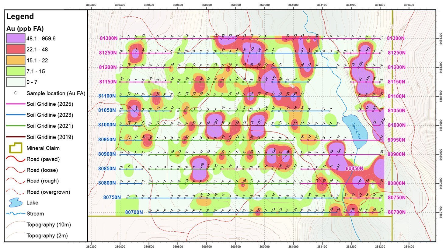 Gold-in-soil results across the Triple R grid
A soil anomaly is an area where soil samples contain more of a metal than the surrounding ground. At the OK Zone, the 2025 work expanded the reported gold, copper and zinc soil anomalies to 600 by 600 metres. The anomalies remained open in all directions, meaning their outer limits had not yet been defined by the sampling grid.
The highest-grade reported sample returned 14,700 ppb Au (14.7 g/t Au) with 953 ppm arsenic. Soil samples from the eastern part of the grid returned up to 1,040 ppb Au, and magnetic surveying identified features for follow-up alongside the soil results.
Chalcopyrite and copper oxides associated with quartz veins were traced over 300 metres. The 2025 program also documented intrusive rocks and historical trenches, pits and an adit.
Mapping documented banded quartz veins and brecciated tuff containing up to 10% pyrite and arsenopyrite, together with historical workings including an adit and cabins.
Soil sampling returned multi-element values of up to 302 ppb Au, 508 ppm Cu, 7,440 ppm Pb and 1,680 ppm Zn in the southwest corner of the grid. The reported anomaly was open to the southwest.
The program included 342 soil samples and 22.9 line-kilometres of ground magnetic surveying across the OK and West grids. Surface sampling and geophysical anomalies are exploration indicators; follow-up work is required to determine their significance and continuity.
Source: Adelphi Metals, September 24, 2025 news release. The technical content of that release was reviewed and approved by Derrick Strickland, an independent Qualified Person as defined by NI 43-101.
2025 Program at a Glance
Building the Exploration Picture
The 2025 program combined mapping, surface sampling and ground magnetic surveying to refine several gold, copper and polymetallic areas for additional exploration.
Follow-Up Areas
Results highlighted the OK, Gateway, Volcano and West areas for additional work.
Metals Reported
The release describes gold, silver, copper and molybdenum mineralization, with lead and zinc also reported in West Zone soil samples.
Field Coverage
342 soil samples supported the 2025 geochemical work reported for the project.
Ground Magnetics
22.9 line-kilometres of surveying covered the OK and West grids.